

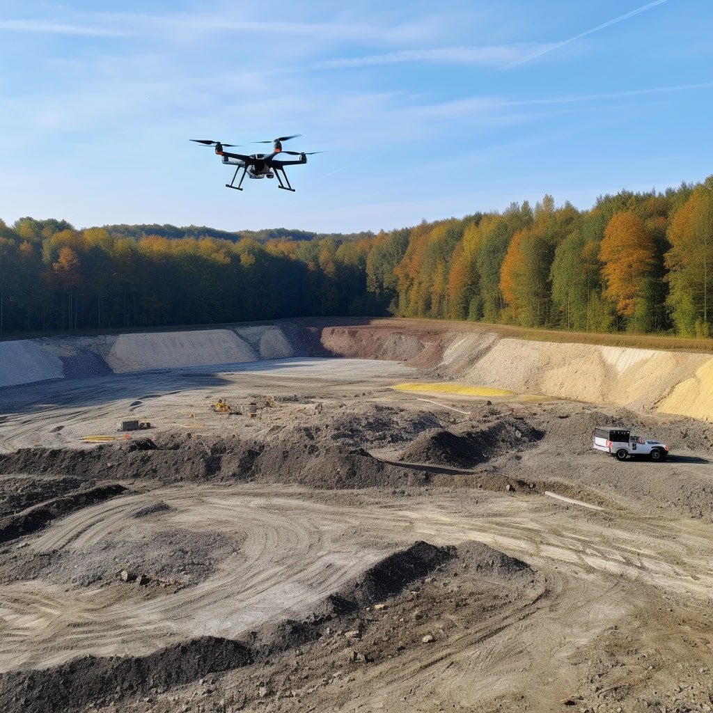
Have you ever wondered how construction companies, land surveyors, or environmentalists collect data and images for their projects? The answer lies in UAV mapping service. Drones equipped with cameras and sensors are used by mappers to capture high-quality images and data for mapping purposes. Flight planning is essential for the success of any UAV mission, ensuring that the drone captures the necessary information. These drones can also create digital surface models, providing accurate and detailed topographical information.
Drone pilots, also known as UAV pilots, are trained professionals who operate the drones during flight to ensure accurate data collection and image capture. This provides a faster, safer, and more cost-effective alternative to traditional mapping methods used by mappers. The collected drone images and data can be used for various applications such as land surveying, construction planning, and environmental monitoring. Additionally, drones can provide highly detailed digital surface models that are useful for a variety of industries.
Drone mapping service, also known as UAV mapping, is becoming increasingly popular among mappers as it offers several advantages over traditional mapping methods. It allows for more efficient data collection in hard-to-reach areas without putting human lives at risk. Moreover, the use of drones provides higher accuracy levels than traditional methods while reducing costs. To ensure successful drone mapping, flight planning and image acquisition are crucial steps that should not be overlooked.
So sit tight and get ready to dive into the world of aerial data and drone mapping service! Our mappers use flight planning to gather survey data that is then transformed into valuable insights for your business.
Benefits of Using Drone Mapping Services for Commercial Aerial Surveying and Engineering Purposes
Increased Efficiency and Accuracy in Surveying and Mapping
Drone mapping services have revolutionized the way commercial aerial surveying and engineering projects are conducted. They offer increased efficiency and accuracy in surveying and mapping, making it possible to complete projects faster than traditional methods. Drones can cover large areas quickly, reducing the time taken for image acquisition significantly. The data collected is also highly accurate, thanks to the advanced technology used in drone mapping services, which results in high-quality work products. Additionally, drones can be utilized for arch inspections, allowing for a more comprehensive analysis of structures.
Drones equipped with cameras capture high-resolution aerial data images of the land or structure being surveyed. These images can be stitched together to create detailed maps that provide a clear picture of the area being surveyed. This level of detail is impossible to achieve using traditional surveying methods, which rely on manual measurements that are prone to errors. Arch aerial technology has revolutionized the way we gather information about our environment.
Drone mapping services allow for efficient image acquisition from multiple angles, providing a comprehensive view of the surveyed area. This makes it easier for engineers and architects in the US to plan construction projects, as they have access to detailed information about the site’s topography.
Cost-Effective Solution for Large-Scale Projects
Another benefit of using drone mapping services from Arch Aerial is that they offer a cost-effective solution for large-scale projects through efficient image acquisition. Traditional surveying methods require significant investment in equipment and labor costs, which can add up quickly when working on large projects.
In contrast, arch aerial drones are relatively inexpensive compared to traditional surveying equipment, making them an affordable option for businesses looking to save costs without compromising quality. Drones can cover more ground in less time than human workers can, reducing labor costs significantly.
By utilizing arch aerial drone mapping services for large-scale projects such as land development or construction sites, businesses can save money while still getting high-quality data that meets their needs.
Enhanced Safety Measures for Workers
One of the most significant benefits of using drone mapping services, such as arch aerial, is enhanced safety measures for workers. Traditional surveying methods often require workers to climb ladders or work in hazardous conditions, which can be dangerous and time-consuming.
Drones eliminate the need for human workers to perform these tasks, reducing the risk of accidents and injuries. This not only improves safety but also increases productivity as drones can operate continuously without breaks. Survey data can further support the benefits of using drones in terms of safety and productivity.
Using drone mapping services also eliminates the need for workers to access difficult-to-reach areas such as rooftops or steep slopes. This makes it possible to conduct surveys on sites that were previously considered too risky for human workers.
Improved Data Collection and Analysis
Drone mapping services offer improved data collection and analysis capabilities compared to traditional surveying methods. Drones are equipped with advanced sensors that can capture a wide range of data, including high-resolution images, thermal imaging, and LiDAR data.
This data can be analyzed using sophisticated software tools that provide insights into the site’s topography, vegetation cover, drainage patterns, and other important factors. The resulting information is highly accurate and detailed, thanks to the use of drone images captured by skilled drone pilots. This makes it easier for engineers and architects to design projects that meet their clients’ needs.
Using drone mapping services also makes it possible to collect data on sites that were previously inaccessible due to terrain or other obstacles. This opens up new opportunities for businesses looking to expand their operations into remote or challenging locations.
Access to High-Quality Imagery and 3D Models
Finally, using drone mapping services provides businesses with access to high-quality imagery and 3D models of the area being surveyed. These models provide a clear visual representation of the site’s topography, allowing engineers and architects to design projects more accurately.
The 3D models generated by drone mapping services are highly detailed and accurate, providing a level of detail that is impossible to achieve using traditional surveying methods. They can be used in conjunction with virtual reality (VR) technology to create immersive experiences that allow stakeholders to visualize construction projects before they are built.
Types of Aerial Mapping Drone Services Available
Photogrammetry Drone Mapping Service
Photogrammetry drone mapping service is one of the most commonly used aerial mapping services. It is a technique that involves taking multiple photographs of an area from different angles and heights and then stitching them together to create a 3D model or map. This type of drone mapping service is ideal for creating high-resolution maps, orthomosaics, and digital elevation models (DEMs). It can be used in various industries such as agriculture, construction, mining, and surveying.
Photogrammetry drone mapping service provides accurate data that can be used to measure distances, areas, and volumes. It also allows users to analyze terrain features such as slope, aspect, and curvature. With photogrammetry drone mapping service, users can easily identify changes in terrain over time.
LiDAR Drone Mapping Service
LiDAR (Light Detection and Ranging) drone mapping service uses laser technology to create highly accurate 3D models of an area. The laser sensors emit pulses of light that bounce off objects on the ground and return to the sensor, providing survey data. These pulses are then used to create a detailed point cloud that represents the area being mapped.
LiDAR drone mapping service is ideal for creating highly accurate topographic maps with elevations accurate down to centimeters. It is commonly used in industries such as forestry management, utility inspection, and urban planning.
Thermal Drone Mapping Service
Thermal drone mapping service uses thermal cameras mounted on drones to capture images of an area’s heat signature. These images can be used to detect temperature differences across an area which can indicate changes in vegetation health or water flow patterns.
Thermal drone mapping service has many applications including identifying areas where heat loss occurs in buildings or detecting hotspots in power lines or solar panels. This type of aerial mapping service is useful for industries such as energy management, environmental monitoring, agriculture, and building inspection.
Multispectral Drone Mapping Service
Multispectral drone mapping service uses cameras that capture light at different wavelengths to create images that can be used to analyze vegetation health, soil moisture levels, and other environmental factors. These images can be used to create detailed maps that show variations in plant growth or water content across an area.
Multispectral drone mapping service is commonly used in agriculture to monitor crop health and identify areas where irrigation is needed. It is also useful in forestry management to detect changes in tree health or invasive species.
Oblique Drone Mapping Service
Oblique drone mapping service involves capturing images of an area from multiple angles and heights. This type of aerial mapping service provides a more comprehensive view of the area being mapped than traditional photogrammetry services.
Oblique drone mapping service is ideal for creating 3D models of buildings or structures. It can also be used for urban planning, real estate development, and disaster response planning.
Capabilities of Drone Mapping Services
High-Resolution Aerial Imagery and 3D Models
Drone mapping services provide high-resolution aerial imagery and 3D models that can be used in various industries. These services use drones equipped with cameras to capture images from different angles, which are then stitched together to create a high-resolution map or model. The images captured by drones are of higher quality than those captured by traditional methods, making them ideal for industries that require detailed maps or models.
Range of Deliverables
Drone mapping services offer a range of deliverables such as orthomosaic maps, digital elevation models, and point clouds. Orthomosaic maps are high-resolution maps created by stitching together hundreds or thousands of individual photos taken by the drone. Digital elevation models (DEMs) are three-dimensional representations of the terrain, while point clouds are sets of data points that represent the surface of an object or area.
These deliverables, obtained through drone data collection by skilled drone pilots, can be used in different industries depending on the drone images captured. For example, orthomosaic maps created from drone images can be used for land surveying and urban planning, while DEMs derived from drone data collection can be used for mining and construction.
Applications in Different Industries
Drone mapping services can be used in various industries such as topographic surveys, infrastructure inspections, and precision agriculture. Topographic surveys involve measuring the shape and features of the Earth’s surface to create accurate maps. Drones can quickly cover large areas and capture detailed information about the terrain.
Infrastructure inspections involve inspecting structures like bridges, power lines, and pipelines to identify any damage or defects. Drones equipped with cameras can easily access hard-to-reach areas like rooftops and towers without putting personnel at risk.
Precision agriculture involves using technology to optimize crop yield while minimizing waste. Drones equipped with sensors like multispectral cameras can capture data about crops such as plant health and moisture levels. This data is then analyzed to make informed decisions about irrigation, fertilization, and pest management.
Real-Time Data and Insights
Drone mapping services provide clients with real-time data and insights that can be used to make informed decisions. With drones, data can be collected quickly and efficiently, allowing businesses to respond to changes in the environment or market conditions. For example, farmers can use drone data to identify areas of their fields that require more irrigation or fertilizer.
Additional Services
Some drone mapping service providers also offer additional services such as data analysis and custom reporting. Data analysis involves processing the data captured by drones to extract useful information. Custom reporting involves creating reports tailored to a client’s specific needs.
Experience Unmatched Precision in Drone Mapping with MetroUAV in Michigan
When it comes to drone mapping services in Michigan, MetroUAV is your top choice. Leveraging the latest technology with DJI Mavic 3 Enterprise and DJI M30T drones, we offer unparalleled precision and quality in data collection. Our experienced UAV pilots, armed with expert flight planning strategies, ensure optimal data capture for your mapping needs. Whether it’s for construction planning, land surveying, or environmental monitoring, MetroUAV delivers high-quality, accurate topographical data, and detailed digital surface models. We blend innovation with efficiency, providing a faster, safer, and more cost-effective solution than traditional mapping methods. Dive into the world of aerial data with MetroUAV, your trusted partner for drone mapping surveys in Michigan.
Aerial Photogrammetry Surveying
What is aerial photogrammetry surveying?
Aerial photogrammetry surveying is a technique that uses aerial data collected by UAVs or drones to create 3D models and measurements of land and construction sites. This process involves capturing images from different angles during a flight, which are then processed to create a digital terrain model (DTM) and point cloud for precise measurements.
How does Arch Aerial specialize in drone surveying?
Arch Aerial, a US-based company, specializes in drone surveying and offers flight planning, image acquisition, and point cloud processing services for accurate measurements and analysis. The company has experience working with various industries such as construction, mining, oil & gas, agriculture, environmental management among others.
The company’s team of experts use advanced technology like high-resolution cameras equipped with GPS systems to capture the images required for the aerial photogrammetry survey. They also use software like Pix4Dmapper Pro to process the data collected into 3D models and other useful outputs.
Where is aerial photogrammetry surveying used?
Aerial photogrammetry surveying using drone images is widely used in construction and land development projects for site planning, progress monitoring, quality control purposes among others. These surveys provide detailed information on the topography of an area including elevation changes that can be used to plan infrastructure projects like highways or buildings. Drone data collection has made it easier and more efficient to obtain accurate and timely information for these surveys.
In addition to traditional ground-based mapping techniques, aerial photogrammetry surveys using drone images and drone data collection are also used in agriculture to monitor crop health or assess damage caused by natural disasters like floods or hurricanes. Environmental management agencies also utilize this technology when mapping out sensitive areas such as wetlands where traditional mapping techniques may not be feasible.
Topographic Surveys
What are Topographic Surveys?
Topographic surveys are a type of land surveying that involves creating detailed maps of land areas. These maps provide valuable information for land planning, analysis, and slope monitoring. Surveyors use traditional methods and advanced technology to collect survey data for topographic maps.
How do Surveyors Collect Data for Topographic Maps?
Surveyors use a variety of tools and techniques to collect data for topographic maps. Traditional methods include using total stations, which measure angles and distances, and levels, which measure height differences between points on the ground. Advanced technology such as drones is also used in modern-day mapping practices. Drones equipped with high-resolution cameras can capture aerial images that are then processed into 3D models or orthomosaic maps.
Benefits of Topographic Surveys
Topographic surveys provide valuable information about the site’s features such as natural terrain, drainage patterns, vegetation coverages, man-made structures like buildings, roads, bridges etc., slopes and contours. This information helps mappers and survey teams identify potential issues and plan accordingly. For example, if a slope is identified as unstable or prone to erosion through the topographical map data collected by surveyors it will be taken into consideration during construction planning.
Topographical surveys, which can now be conducted using drone data collection, can also help identify potential flood-prone areas through drainage patterns identified in the mapping process.
In addition to this crucial planning function topographical surveys can also be used for environmental purposes such as identifying wetlands or other protected areas that need special attention during development projects.
Cost of Requesting a Topographical Survey
Requesting a topographical survey can be costly depending on the size of the area being surveyed among other factors but it is important to note that accurate survey data and maps can outweigh the cost in the long run especially.
It is always best practice to request an estimate from your drone mapping service provider to get a better idea of what the cost will be. Be sure to communicate your specific needs and project requirements so that the survey team can provide you with an accurate quote.
Utilizing Drone Mapping Services with GIS Technology
Highly Accurate and Detailed Maps
Drone mapping services offer a new way of creating highly accurate and detailed maps. The process involves using drones equipped with cameras and sensors to capture aerial images and data. These drones can capture data from areas that are difficult or impossible to reach by traditional means, such as rugged terrain or inaccessible infrastructure.
The captured data is then processed using Geographic Information System (GIS) technology. This technology allows for the creation of maps that are more accurate than traditional methods. By combining drone mapping services with GIS technology, businesses can create maps that are highly detailed and provide a wealth of information.
Process and Analysis
GIS technology is used to process and analyze the data captured by the drones. This allows for the creation of maps that can be used in a variety of industries. For example, utilities companies can use drone mapping services to create maps of their infrastructure. These maps can help them better manage and maintain their assets.
Other industries that can benefit from drone mapping services include agriculture, construction, and environmental management. In agriculture, drone mapping services can be used to monitor crop health, identify problem areas, and plan irrigation systems. In construction, they can be used for site planning and monitoring progress. In environmental management, they can be used for ecosystem monitoring and conservation efforts.
Saving Time and Money
By utilizing drone mapping services with GIS technology, businesses can save time and money while also improving the accuracy and quality of their mapping services. Traditional methods of map creation often involve extensive fieldwork which is both time-consuming and expensive.
Drone mapping services eliminate much of this fieldwork by capturing data from above with greater speed than traditional methods allow. This saves businesses time while also reducing costs associated with labor-intensive fieldwork.
Moreover, the accuracy provided by these new technologies reduces errors in map creation which could have led to costly mistakes in decision-making processes based on inaccurate maps.
Industries Benefiting from Drone Surveying Services
Agriculture
Drone mapping services have revolutionized the way farmers monitor their crops. By using drones, farmers can quickly identify areas of stress and optimize irrigation and fertilization. Drones equipped with specialized sensors can capture detailed images of crops, allowing farmers to detect problems such as nutrient deficiencies, pests, and disease. This data helps farmers make informed decisions about crop management practices, resulting in higher yields and increased profits.
Construction
Drones are transforming the construction industry by providing real-time data on construction sites. With drones, project managers can quickly survey a site and gather information on progress, safety concerns, and potential issues before they become major problems. This allows for more efficient planning and monitoring of projects. Drones equipped with cameras can also capture high-resolution images of structures, allowing for detailed inspections without putting workers at risk.
Mining
Mining companies are using drone surveying to map out terrain, monitor excavation progress, and ensure compliance with safety regulations. Drones equipped with specialized sensors can collect data on topography and geology that would be difficult or impossible to obtain using traditional surveying methods. This information helps mining companies make informed decisions about where to excavate next, how to manage waste products safely and efficiently, and how to minimize environmental impact.
Oil and Gas
The oil and gas industry is leveraging drone technology for pipeline inspection, rig monitoring, and environmental surveys in hard-to-reach areas. Drones equipped with cameras or thermal imaging sensors can inspect pipelines for leaks or damage without interrupting operations or requiring workers to climb up dangerous heights. They can also provide real-time data on oil rigs’ condition while reducing the need for human intervention in hazardous environments.
Real Estate
Drones are changing the game in real estate by capturing high-quality aerial footage of properties from unique perspectives that were previously impossible or expensive to obtain. Potential buyers can now view properties from the air, providing a comprehensive view of the property’s location, neighborhood, and surroundings. Real estate agents can also use drone footage to market their listings more effectively, showcasing features such as pools, gardens, and views that are not visible from the ground.
Surveying and Mapping
Drone surveying services can quickly and accurately map out large areas of land with high precision. Drones equipped with GPS technology can fly pre-programmed routes over an area to capture detailed images that can be used to create 3D maps or models. This data is useful for planning infrastructure projects such as roads, bridges, and buildings. It is also valuable in assessing natural resources such as forests, waterways, and wildlife habitats.
Aerial Mapping & Surveying Industries Served
Agriculture: Crop Monitoring, Yield Estimation, and Soil Analysis
Drone mapping services have become increasingly popular in the agriculture industry due to their ability to provide accurate data on crop health, yield estimation, and soil analysis. With drone technology, farmers can easily monitor their crops’ growth and health by capturing high-resolution images of their fields. These images can be analyzed using specialized software that provides detailed information on plant health, including stress levels, nutrient deficiencies, and disease outbreaks.
Farmers can also use drone mapping services to estimate their crop yields accurately. By analyzing the data collected from drone surveys, farmers can determine how much of their crops will be harvested and make informed decisions about how much to sell or store for later use.
Another significant benefit of using drone mapping services in agriculture is soil analysis. Drones equipped with specialized sensors can collect data on soil moisture levels, pH levels, and other critical parameters that affect plant growth. This information helps farmers understand which areas of their fields need more attention and what types of fertilizers or other treatments are needed to improve crop yields.
Construction: Site Surveying, Progress Tracking, and Quality Control
Drone mapping services are also widely used in the construction industry for site surveying, progress tracking, and quality control purposes. Drones equipped with high-resolution cameras can capture detailed images of construction sites at various stages of development. This allows project managers to track progress accurately and identify any potential issues before they become major problems.
In addition to tracking progress, drones can also help ensure quality control on construction sites. By capturing high-resolution images of building components such as roofs or walls during construction phases or after completion for inspections purposes; engineers and architects can quickly identify any defects or errors in the workmanship.
Site surveying is another area where drones excel in the construction industry. Instead of relying on traditional surveying methods that require time-consuming manual measurements, drones can quickly and accurately capture data on site topography, elevation changes, and other critical parameters. This information helps architects and engineers design more efficient buildings that are better suited to their surroundings.
Mining: Exploration, Stockpile Measurement, and Environmental Monitoring
Drone mapping services have revolutionized the mining industry by providing accurate data on exploration sites’ topography and geology. By using drones equipped with specialized sensors such as LIDAR or magnetometers; mining companies can collect detailed information on mineral deposits‘ location and composition. This allows them to plan more efficient extraction methods that minimize waste and reduce environmental impact.
Stockpile measurement is another area where drone mapping services have proven invaluable for the mining industry. Drones equipped with high-resolution cameras can quickly capture images of stockpiles of minerals or other materials, allowing companies to estimate their volume accurately. This information is essential for planning transportation logistics and ensuring that production levels meet demand.
Environmental monitoring is also a crucial area where drone mapping services can help mining companies comply with regulations while minimizing their impact on the environment. Drones equipped with specialized sensors can collect data on air quality, water quality, noise levels, and other critical parameters that affect local ecosystems’ health.
Oil & Gas: Pipeline Inspection, Facility Monitoring, and Environmental Compliance
The oil & gas industry has also embraced drone mapping services due to their ability to provide accurate data on pipeline inspection sites’ condition. Drones equipped with high-resolution cameras can quickly capture images of pipelines from various angles; this allows inspectors to identify any potential issues such as corrosion or leaks quickly.
Facility monitoring is another area where drone mapping services excel in the oil & gas industry. By capturing high-resolution images of facilities such as refineries or drilling rigs; operators can monitor equipment performance remotely without risking personnel safety in hazardous environments.
Finally, environmental compliance is another significant benefit of using drone mapping services in the oil & gas industry. Drones equipped with specialized sensors can collect data on air quality, water quality, and other critical parameters that affect local ecosystems’ health. This information helps companies comply with regulations while minimizing their impact on the environment.
Accurate Data Collection through Aerial Mapping Services
Aerial Mapping Services: Providing Accurate Data Collection for Various Industries
Aerial mapping services have become an essential tool for various industries, including construction, mining, agriculture, and environmental monitoring. These services use drones to collect data from the air, providing high accuracy and precision that cannot be achieved through traditional methods.
The use of drones in data collection has revolutionized the way industries gather information. Drones can fly at different altitudes and capture images with high-resolution cameras. These images are then processed using specialized software to create 2D or 3D maps of the area being surveyed.
High Accuracy and Precision: The Benefits of Drone Technology in Data Collection
One of the most significant advantages of drone technology is its ability to provide accurate and precise data. Drones can capture images with a resolution as high as one centimeter per pixel, which is much more detailed than satellite imagery or ground-based surveys.
The accuracy of the collected data is crucial in ensuring the success of projects that rely on this information. For example, in construction projects, accurate surveying is necessary to ensure that buildings are constructed on stable ground and within legal boundaries.
Valuable Information for Decision-Making Processes
The collected data can be used to generate valuable information for decision-making processes. For example, land surveying can help identify areas suitable for development or conservation efforts. Infrastructure inspection can help detect potential problems before they become major issues that could impact public safety.
Environmental monitoring can help track changes in ecosystems over time and identify areas where conservation efforts may be needed. By providing accurate and up-to-date information, aerial mapping services enable stakeholders to make informed decisions about resource management, planning, and development.
Efficient Data Collection: Saving Time and Cost
Aerial mapping services can cover large areas quickly and efficiently using drones equipped with high-resolution cameras. This reduces the time and cost associated with traditional data collection methods, such as ground-based surveys or manned aerial photography.
For example, in agriculture, drones can quickly scan large fields to identify areas that may need additional irrigation or fertilization. This information can be used to optimize crop yields and reduce waste.
Versatile Applications: Land Surveying, Infrastructure Inspection, and Environmental Monitoring
The collected data from aerial mapping services can be used for various applications such as land surveying, infrastructure inspection, and environmental monitoring.
Land surveying using drones is a cost-effective way to map large areas of land quickly. The data collected can be used to create accurate topographic maps that are essential for planning development projects or identifying areas suitable for conservation efforts.
Infrastructure inspection using drones can help detect potential problems with structures such as bridges or buildings before they become major issues. By providing detailed images of the structure’s condition, engineers can identify areas that may need repair or replacement.
Environmental monitoring using drones allows researchers to track changes in ecosystems over time. This information is critical in identifying areas where conservation efforts may be needed and assessing the impact of human activities on natural resources.
High-Resolution Digital Mapping Products for Your Industry
Accurate and Detailed Maps for Various Industries
High-resolution digital mapping products provide accurate and detailed maps that are essential in various industries such as construction, agriculture, and mining. The use of drone mapping technology enables the production of work products that are more efficient, cost-effective, and environmentally friendly.
Digital surface models generated by drone mapping software can be used to create precise 3D models of terrain and structures. This allows industries to plan their work effectively by identifying small details that may be missed by traditional mapping methods. With high-resolution maps, businesses can make informed decisions based on accurate data.
For instance, construction companies can use high-resolution digital maps to survey potential building sites before starting any project. These maps provide information about the topography of the land, which helps engineers design buildings that are structurally sound. Similarly, farmers can use these maps to monitor crop growth and identify areas that require irrigation or fertilizer.
Essential for Planning and Monitoring Work
Industries such as construction, mining, and agriculture rely on high-resolution digital maps to plan their work effectively. For example, mining companies need accurate maps to locate mineral deposits underground. These maps help miners determine where they need to dig tunnels or drill holes to extract minerals.
Similarly, construction companies use high-resolution digital maps to plan the layout of buildings before starting any project. This helps them identify potential obstacles such as trees or rocky terrain that may hinder construction progress.
In addition to planning work activities, these digital mapping products are also essential for monitoring ongoing projects. For example, farmers can use drones equipped with cameras to capture images of their crops from above. By analyzing these images using specialized software, farmers can identify areas where crops are stressed due to lack of water or nutrients.
Cost-Effective and Environmentally Friendly
The use of drone technology in creating high-resolution digital mapping products is not only cost-effective but also environmentally friendly. Compared to traditional mapping methods that require the use of manned aircraft or ground-based surveying equipment, drones are more efficient and less expensive.
Drones can cover large areas quickly and capture data with high accuracy. This reduces the time required to create maps and lowers the cost of producing them. Drones do not emit harmful pollutants or contribute to noise pollution, making them an environmentally friendly option for creating digital mapping products.
The Advantages of Drone Mapping Service for Your Industry
Drone mapping service is a game-changer for industries that require accurate data collection, high-resolution digital mapping products, and efficient surveying methods.
Benefits of Using Drone Mapping Services for Commercial Aerial Surveying and Engineering Purposes
Drone mapping services offer numerous benefits to industries that require quick and accurate data collection. With drones, you can collect data in areas that are difficult or impossible to reach with traditional surveying methods. This makes it an ideal solution for industries such as construction, agriculture, mining, oil and gas exploration, environmental monitoring, and more.
Using drones also reduces costs associated with traditional surveying methods such as hiring personnel or renting equipment. Drones can cover large areas quickly while providing high-resolution images which can be used to create 3D models or topographic maps.
Types of Aerial Mapping Drone Services Available
There are several types of aerial mapping drone services available depending on your industry needs. These include photogrammetry surveys which use overlapping images to create 3D models or orthomosaic maps; topographic surveys which measure elevation changes; LIDAR surveys which use lasers to capture detailed terrain information; thermal imaging surveys which detect temperature differences on surfaces; and multispectral surveys which capture different wavelengths of light to identify vegetation health.
Capabilities of Drone Mapping Services
Drone mapping services offer various capabilities such as real-time data collection, high-resolution imagery capturing up to one centimeter per pixel resolution at low altitudes (depending on the camera), post-processing software that allows you to create 2D/3D models or orthomosaic maps from captured images. They are also equipped with GPS technology that provides accurate location data for each image captured.
Industries Benefiting from Drone Surveying Services
Drone surveying services benefit industries such as construction, agriculture, mining, oil and gas exploration, environmental monitoring, urban planning, and more. These industries require quick and accurate data collection to make informed decisions about their projects.
Aerial Mapping & Surveying Industries Served
Drone mapping services serve various industries such as real estate development, forestry management, wildlife conservation, disaster response teams, insurance companies for claims adjustment purposes.
Accurate Data Collection through Aerial Mapping Services
Aerial mapping services provide accurate data collection that can be used to create 2D/3D models or orthomosaic maps. With drones equipped with GPS technology and post-processing software that allows you to stitch images together seamlessly. You’ll have access to high-resolution imagery that can be used for detailed analysis of terrain features or vegetation health.
High-Resolution Digital Mapping Products for Your Industry
With drone mapping services you get high-resolution digital mapping products that are perfect for your industry needs. Whether you need a topographic map or an orthomosaic map the resolution is up to one centimeter per pixel at low altitudes (depending on the camera). This means you get highly detailed imagery that can be used in any project requiring accurate data collection.
FAQs
How do I choose the right drone mapping service provider?
When choosing a drone mapping service provider look at their experience in the industry and what types of surveys they offer. Also consider their equipment and software capabilities as well as their safety protocols.
What are some common applications of drone mapping services?
Drone mapping services are commonly used in applications such as construction site monitoring, agricultural crop health assessment, mining operations management, oil and gas pipeline inspections among others.
How much does it cost to use a drone mapping service?
The cost of using a drone mapping service varies depending on factors such as the size of the area to be surveyed, type of survey required, and the level of detail needed. It’s best to get a quote from your chosen drone mapping service provider.
Are drone mapping services safe?
Yes, drone mapping services are safe when operated by licensed and experienced professionals who follow safety protocols.
How long does it take to complete a drone mapping survey?
The time it takes to complete a drone mapping survey depends on the size of the area being surveyed and the level of detail required. However, drones can cover large areas quickly which means surveys can be completed in less time compared to traditional methods.
Ready to harness the power of drone mapping for your project? Contact us today to explore efficient, accurate drone solutions tailored to your specific needs. Let’s revolutionize data collection together!